We are pleased to announce our latest publication in the journal GeoHazards. The paper highlights how climate change, limited forest and fuel management, urban expansion into wildland areas, and rural abandonment have collectively intensified wildfire risk across the country. It also explores how the longstanding emphasis on fire suppression, combined with legislative and administrative complexities, has slowed progress toward effective prevention and coordinated response strategies.
A central focus of the study is the need to transition from a suppression-centered approach toward integrated wildfire prevention and landscape resilience. The article discusses:
- The importance of proactive fuel and forest management;
- The development of fire-resilient landscapes;
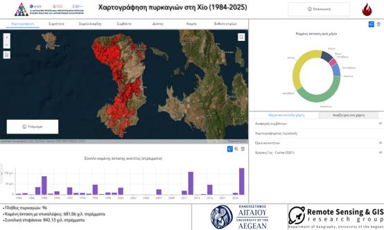
- The adoption of advanced technologies and geospatial tools;
- Improved coordination among stakeholders and agencies;
- Landscape-scale wildfire mitigation strategies;
- Contributions from the EU-funded FIRE-RES project.
The research underlines the critical role that remote sensing, GIS, spatial analysis, and collaborative environmental management can play in reducing wildfire impacts and supporting long-term resilience.
🔗 Read the full article: https://www.mdpi.com/2624-795X/7/2/55