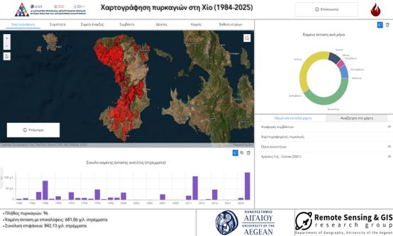

The Remote Sensing and Geographic Information Systems (RSGIS) Research Group of the Department of Geography, University of the Aegean, has developed an interactive Web GIS application to support wildfire management in the island of Chios. The application was created as part of the educational and research activities of the Research Group and is available at https://www.chios-fires.com.
The platform was developed by Stylianos Tzannis as part of his Master’s thesis in the Inter-Institutional Master’s Programme Natural Hazards and Disaster Management, under the supervision of Asst. Prof. Christos Vasilakos.
The Web GIS integrates heterogeneous geospatial datasets from multiple national and international sources into a unified environment, providing users with interactive visualization, exploration, and management of wildfire-related information. It is designed to support continuous data updates and future spatial expansion, ensuring that the platform remains up to date with operational requirements.
The application currently provides access to:
- Burned area mapping (1984–2025)
- Wildfire occurrence frequency (1984–2025)
- Wildfire ignition points (2020–2024)
- Incident reporting and visualization
- Fire weather indices
- Real-time meteorological information from weather stations, satellite imagery, and weather radar
- Building exposure to wildfire risk
The platform is primarily intended to support Civil Protection authorities, Fire Services, and other stakeholders involved in wildfire management. At the same time, it serves as a valuable tool for informing and raising public awareness about wildfire prevention, preparedness, and response.
This initiative demonstrates the potential of Geoinformatics to enhance situational awareness, support evidence-based decision-making, and strengthen wildfire risk management through modern geospatial technologies.