
Building exposures to wildfires
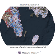
The increasing frequency of wildfires with high intensity and fast spread rate can significantly raise the exposure and risk of buildings and structures. This is particularly critical in the wildland-urban interface (WUI), where communities face high fire related risk and frequently suffer from devastating losses on property, assets and human lives. Asst. Professor Christos Vasilakos from the RSGIS group in collaboration with Asst. Professor Paleologos Paleologou (Agricultural University of Athens), have developed interactive web maps that can aid to the identification of wildfire-prone areas across Greece. The methodology applied involved: a) Wildfire Simulations: Over 66 million random fire ignitions were simulated across Greece under three different weather scenarios (Low, Medium, and High), generating fire perimeters for each ignition with associated information depicting wildfire intensity (flame length); b) Building Footprint Data: Building polygons were extracted from satellite imagery (Bing Maps) using Machine Learning techniques provided by Microsoft; c) Bivariate Mapping: The number of buildings and wildfire perimeters was estimated within 500 × 500 m grid cells, classifying them into Low, Medium, and High risk levels. The resulting bivariate web maps visually represent areas with high building density and frequent wildfire occurrences, helping to assess exposure and support wildfire risk mitigation efforts.
Explore the maps here to gain insights into wildfire-prone areas of Greece and the potential impact of fires over the built environment..