
Burned/Unburned olive trees
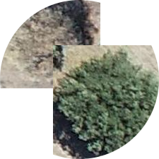
Dataset includes 3624 images of burned and unburned olive trees. These images are subsets of UAV images acquired by (a) Phantom-4 PRO RTK, (b) Phantom-4 Multispectral RTK (RGB sensor), and (c) Lidar L1 (using the optical spectrum sensor) mounted on a MATRICE 300 RTK (DJI. The aforementioned flights were conducted at various altitudes, resulting in data with different Ground Sampling Distances (GSDs). The burned trees were identified by visual interpretation of UAV images and field trips in two states: either partially burned, where part of the canopy was damaged while the remaining portion stayed healthy (green foliage), or fully damaged, where the entire canopy was affected. The dataset was prepared and used for training a CNN for image classification.
Dataset can be downloaded from Mendeley Data repository here.
If you use this dataset, the below citations should be used:
- Vasilakos, Christos (2025), “Aerial images (UAV) of burned and unburned olive trees”, Mendeley Data, V1, doi: 10.17632/83kpndkrb2.1
- Vasilakos, C., Verykios, V.S. 2024. Burned Olive Trees Identification with a Deep Learning Approach in Unmanned Aerial Vehicle Images. Remote Sensing. (16):4531.