
Fire Ignitions in Greece > 2020
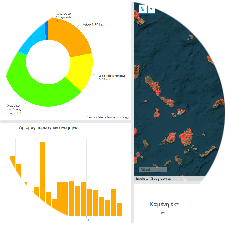
As part of previus projects, an effort was made to visualize open data provided by the Fire Service on the ignition points of wildfires in Greece in a modern, effective, and sophisticated way. A GIS dashboard was developed to present the historical record of wildfire ignition points, incorporating all available information for each event. The visualization environment is fully interactive, allowing users to access a comprehensive dataset from 2020 onwards. The fire ignition database is continuously updated and can be accessed here.